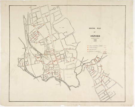
This intriguing 1883 map appears to offer a guide to the pubs of Victorian Oxford, similar to tourist maps today. Beerhouses, breweries and other licensed premises are all shown.
But this wasn’t the original intention. Published in by the Temperance Movement, the map was designed to show how the poorer areas of Oxford were heavily populated with drinking establishments and the text explains the detrimental effect of alcohol on local inhabitants.
Our speaker Stuart Ackland has worked in the Map Room at the Bodleian Library since 1990. He looks after the storage of the collection and helps run a blog dedicated to the maps held in the Bodleian. He will be talking about the Drink Map of Oxford and what it tells us about the social history of the city.
This talk will be in the pub and not recorded